Top Hiking areas in Pelsor, United States
Top Rated Hiking areas in Pelsor

Top Reviewed Hiking areas in Pelsor
Reviews

The trails were well marked. A couple of fields to cross with views of the surrounding hills. Rough dirt road to get there. Most people just parked on the side of the road.
Great hike though meadows and woods to beautiful falls and caves to explore. Several water crossings. Well worth the trip!

Great easy hike. But for Pete sake if you go to hike in a National forest during hunting season (Nov. & Dec) please wear some safety orange.


This is a beautiful trail with lots to explore. Under the pedal rocks are some caves that are fun to explore. I would recommend taking the loop to the rocks first to take the easy route back at the end of this 2 mile hike.


Loved this trail! Beautiful views and a lot less crowded than the more popular trail in the area, Hawksbill Crag/ Whitaker Point.


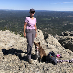
Great place anyone that is in okay shape should be fine on the trails. Great fall colors this trip. Late October. If you are in good shape exploring the base of the cliffs is quite the adventure.

Very nice place to visit


This loop trail is about 2.6 miles according to my Apple watch. The parking lot holds about 4 cars and there is a picnic table. This trail is very well marked and appears to be maintained. Still, there are plenty of rocks and roots and there is a significant elevation drop down to the cliff area and whosoever walks down must then walk back up. There are multiple “Pedestal rocks” at the end of the loop. Many of the cliffs have no guard rail so watch children carefully. It does not appear that there is any cell coverage. Nice one hour hike. We did not take the Kings bluff trail but that is also available here. Highly recommended.


Awesome hike in the Ozark St. Francis National Forest! Love the scenery, the rock formations, the caves and the views!!!


The rock features and caves make this a wonder-filled hike any time of year. Leaf-off has spectacular views along much of the trail. Wet weather adds gorgeous falls. Easy hike with a good amount of parking. NP toilet facility near trailhead.


Amazing. Had no idea this place existed until a few weeks ago. Sorry I didn't go sooner. I'll definitely go back. Thick trees so would like to go late fall or early spring. It's a bit of a walk from the parking area (a mile or so) but the trail is wide and well-marked and very little elevation change so it's not a hard trek.


Wasn't a terrible hike but there were a couple spots with trees blocking the path. One spot in particular the tree and branches were covering the path to the point where you had to trek through the downed tree. Bees were buzzing around it so we made it through as quick as possible. When we saw the sign for pedalstal trail we went right and came back up the left side. Not too sure if it was easier this way or not. Took us about an hour and a half with stopping for photos.

After a week in Arkansas disappointed by our waterfall hikes (yes, Memorial Day week is too late in the year we now realize) this hike really delivered. There are two WFs indicated on the AllTrails map were both very satisfying. Plus, there were orange tape markers and that distinct waterfall noise which indicated that there is a 3rd waterfall north of the first one, but I ran out of time to pursue it. The hike in is very pleasant. A stroll through 4 verdant meadows with waist-high grass surrounded by idyllic woods and hills. I worried that would be tick-city but I did not get any on me. After the meadows the trail ran alongside a babbling creek. I hiked in sandals for the creek crossings but that was not necessary. Someone left orange tape along the main trail indicating points of interest off to the side - take those side trails! I would recommend against taking a front wheel drive car off Hwy 7 down to the trailhead - there were several patches of very steep road with loose gravel.

Beautiful area.

Went camping here and absolutely loved it. Secluded, unimproved, free campsites all along the river on CR1250 with easy access to several trailheads. Quite a few small falls within reasonable hiking distance.

Beautiful area. Road is a bit rough and steep coming down. I would not want to try it in a car. We loved all of the different things the explore. Be prepared for at least 3 different water crossings.
Absolutely beautiful!

We hiked this trail again on Christmas Eve 2021. It was warm and sunny on our second visit, and we were determined to see some of the sights we missed out on when we hiked it in 2020. After visiting Big Creek Cave Falls we set out to find Wolf Creek Cave Falls. These falls come out of a cave opening too. Two cave falls on a single hike is well worth the trip.
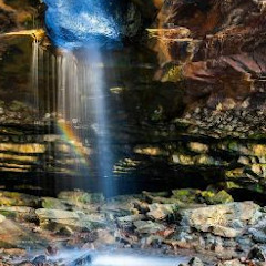
We hiked this in mid-November 2021. The photo is below Lower Horsetail Falls. The trail has some elevation change, but nothing too bad. Climbing to the falls was a little difficult due to all the leaves that had fallen. It was hard to see the trail. It seems this trail doesn't see a lot of traffic. To find Lower Horsetail Falls you can find the trail up the drainage on the left, opposite a large rock and a trail leading to a cascade waterfall on Falling Waters Creek. This is a 70' waterfall, so it would be a good one to see during the rainy season.

Nice muddy well maintained trail with a great ending and interesting rock formations with 2 waterfall views

Great hike thanks to someone on the interwebs that had photos, accurate GPS coordinates and landmarks. I wish I could give credit but my husband planned this hike. I didn't have anything to do with it. 4 miles round trip. Road to trail looks sketch, like its someone's driveway.... but just keep going. Go way down....Park off to the right of the road by an old aluminum gate... and start your hike. Old cement bunker at the start. Marked with some flagging tape at each fork and sometimes rocks stacked or in the formation of an arrow. We really enjoyed it. Easy hike. We are not seasoned hikers.

This is a nice easy hike. Park across the bridge and walk back, the trail is to the right. After a rain, parts of the trail will be very muddy, yet nothing difficult, just mud. A side trail leads down to the west side of Six Fingers Falls. Go see that and come back up to the trail and continue. You will come to the short trail to Fuzzybutt Falls to the left. The horse trail continues after that yet we came back. About a mile from the bridge to Fuzzybutt, it's an out and back trail.

Park in the parking area across the bridge. You may enter into the woods on the West side of the creek. The horse trail is marked with green blazes.
The trail takes off to the right and into the woods. The trail follows along the creek for a bit, and crosses a smaller creek and a small waterfall. If you go up this creek to the left, you will eventually get to Horsetail Falls.
The trail takes off to the right and into the woods. The trail follows along the creek for a bit, and crosses a smaller creek and a small waterfall. If you go up this creek to the left, you will eventually get to Horsetail Falls.

This is an amazing waterfall flowing out of a cave in the side of the mountain! A great example of how the Limestone in the Ozarks creates karst characteristics and caves. A fascinating hike