Best Hiking areas in Canada
Top Rated Hiking areas
Top Reviewed Hiking areas


FortWhyte Alive
Burnaby Mountain Biking and Hiking Trails
Velodrome Trail
Trans Canada Trail
Fraser Heights Vistas Nature Trail
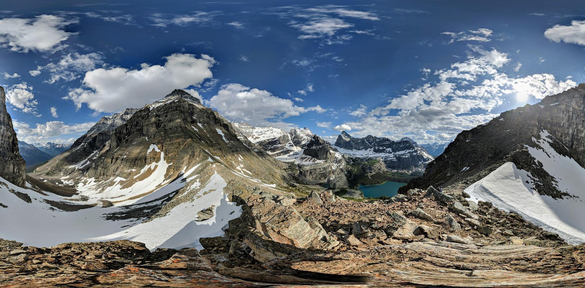
Coquitlam Lake View Trailhead
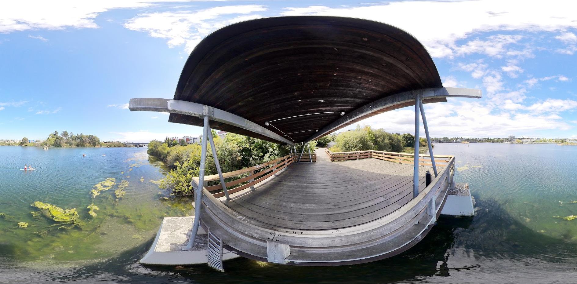
Southshore Trail
West Forest Trails
Byrne Creek Urban Trail
South Side Trail
Pinhey Forest
River Loop Trail
Reviews

It is difficult to find the way and no view of the lake has been found.

Another nice place along the river valley to do many other outdoor activities.


Trail Series, Part 26
The Burnaby Mountain Trail has made me begin to wonder if I am developing a serious dependence on the British Columbia trail system. You see it doesn’t seem to matter how many of them I run, I only seem to long for more.
This location features a series of interconnected trails that are mostly technical in nature. I believe they can best be described as mountain bike trails that you are allowed to run or hike on. There are multiple bike jumps to navigate, numerous bridges to cross, frequent rocks and roots to avoid, and the downhills are fairly steep. Strollers and wheelchairs are not recommended and those with mobility issues would likely prefer to avoid this venue.
Although you’ll be surrounded by a dense blanket of trees, the trail offers occasional glimpses of some of the high rises in the greater Vancouver area.
I found ample available parking on the adjacent Simon Fraser University campus for a nominal fee.
If you’re ready for a technical run (or ride), this place is for you.
And that’s…Henry’s Take.
#vancouvertrails


What a beautiful hike it is, one should must go and enjoy


Pretty quite for a Sunday! Going back, we found the biking trail and hiking are different! Hiking trail was very beautiful!

Good trek, well marked. Just go on a day with sunshine 😅, I've been twice in fog, and will have to go again to catch that view!


One of the best things Winnipeg has to offer! From the birds and bison, to the gift shop, cafe, interpretive center and all it’s amazing programs, workers and volunteers; it’s nirvana. Cheap too for a day of outdoor education and serenity! Or free if your like me and walk/bike in!! I could go on for pages about how special this place is. If I could give more than 5 ⭐️, it would be infinitely (and still not enough). This is literally my happiest place on earth. ☀️🌲

if i could give zero i would.


It's not the most mind-blowing trail, but it's a cool spot for some fresh air and nature vibes. It's not deep in the jungle, so you'll catch some sun along the way. I think I'm not a fan of the lake because of all the lilipads. Overall, not a bad choice for a chill weekday walk!

No thing outstanding just so so


A peace of heaven. Stairs were a good practice of hiking with great views and surroundings


Nice view... the maples are golden in November....

Like a hidden gem of nature in the area.

If you're going mountain biking and torn between 2 locations, pick the other location over Burnaby. Lots of the trails are permanently closed, the only fun trail was Lower snake. Will not be returning, one time is enough for me.


Fun and easy to navigate trail. Be aware there is quite a lot of bicycle traffic if your walking the trail. Most are sensible and share the trail politely but there are some fast cyclists that think they own the trail and come fast around the corners.


Great easy hiking trail with multiple loops. Good weekend hike for families with kids. Gotta pay park up at SFU and walk down.

This is the trail around Fort Edmonton Park. A nice short walk that gets you close to the river edge. Mostly shaded on well kept gravel path. Parking is nice and easy as you can use the main Fort Edm. lot. Another of the many excellent walking trails in our extensive Edmonton trail systems. I recommend!


This loop is Lord Selkirk trail to Ft Edmonton park bridge, to Wolf Willow stairs (200 steps up/down), then back across the bridge, and return on Ft Edmonton trail. 6 Kms total plus stairs.


Not really worth going here unless you are a Fraser Heights resident. First, there is no parking avail for the park, only the street neighborhood parking. Second, the walk is extremely short though somewhat nicely natured. Third, view point didn’t offer much views, just tree branches blocking highway scenes. Also, noise can be heard due to highway #1 being right nearby. If you are intentionally coming here from outside the town to see what is being offered at this park, just know this will be just 10-20 min short walk with not much to be inspired of.


Peaceful walk in the center of the city


Dangerous for inexperienced hikers. It's a rocky, slippery mess in the beginning and then a poorly marked "deer trail" at higher elevation. The view of the lake, once on top, is spectacular.

Awesome view , fantastic and unique marsh , perfect for hiking , pretty easy to access, I was happy to find this place.


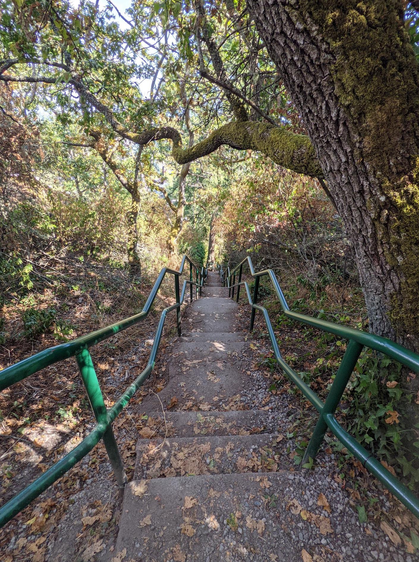
Great exercise trail with more than 500 stairs! The incline is worth about 1/4 of the Grouse grind. This is perfect trail for winter months when lots of other hiking trails are unsafe.
I always start from mountain air park where parking is abundant. Be sure to go all the way up to the Burnaby mountain to enjoy the view!
I always start from mountain air park where parking is abundant. Be sure to go all the way up to the Burnaby mountain to enjoy the view!


Really nice place to recap and refresh your mind !
What a wonderful walk. My only concern is that the ebikes use this shared trail. They are operating at speeds faster than you can react to. We had our dog on a leash and there were close calls. It's a shared trail, but "shared
"means everyone is going to collide at some point. Check out the fort Edmonton foot bridge. Very nice.
"means everyone is going to collide at some point. Check out the fort Edmonton foot bridge. Very nice.


With over 500 steps, it can be a bit tricky to get around when it’s raining. The view from the trail is amazing and totally worth it. As a beginner, I found it pretty tough, but I saw other hikers who were actually running. There are facilities and parking at the top at Burnaby Mountain Park. Overall, it was an awesome experience and a great workout.


Amazing views and a good practice for grouse grind


No snow on 1 Apr 2023.
Beautiful network of trails.
Shooting range at the entry point of trail so you keep hearing gun shots continuously.
Lot of small waterfalls. Did the woodland walk till Pritchett creek cascades falls bridge. Easy walk 4 km loop. Beautiful view. Steep in the beginning. Parking is roadside only. Lots of people do the biking. Multiple loops, look at the poles and small markers on them for right directions.


The Southside trail isn't too interesting and goes near the highway so you hear the noise. Parking was for around 30 cars.


Fortwhyte Alive is the perfect quintessential Canadian winter afternoon hang out. Snow shoes. Paths. Investigating a frozen Marsh. The lakes were mainly frozen. The sledding run is terrifyingly fun (or just terrifying depending on who you are). The interactive center is excellent - love staring into the dark, deep waters at some local fish. Great afternoon.


A very neat and wonderful place to visit. Plenty of hiking trails here and great views of downtown and Port Coquitlam and other places.
You have got to visit this for sunset time. I did take some photos. I hope you all like them
You have got to visit this for sunset time. I did take some photos. I hope you all like them


Lots of snow right now but still a fun trail but do dring a warm coffee with ya 😉 ☕️


It's a fun area. Some really lovely trails. I bring my dog & we had a blast yesterday running down snowy hills & through snow drifts. Families were up there with their kids. Was a nice wintery day.
"Cramp ons": If there is snow or ice buy a pair. Basically snow chains for your shoes.
We were able to run down a fairly steep decline.....no problem. A MUST for winter hikes.
I do the Grouse Grind a lot, there is a 1+ km section called "Trans Canada Trail". Nice winter Grind training. Hamstrings were pumped! Did a couple up & downs. Great!
Glad I tried the area. Can't wait for spring to really run through there.

Quieter trail if you are looking to get away from the Deer Lake crowds
Apparently you "can't bring your car"


What a Gem...Absolutely Beautiful and Peaceful..Yes lots of Trees down...but the paths are clear..Been coming here since the 80's

Beautiful and short hike that's a little hilly


The map and marks not very clear. Some time I almost lost. Anyway the views are wonderful and trails are quite and peaceful.


Great hike close to the city, nice South Western view from the Coquitlam Lake lookout. Waterfalls, lots of thick forest and trails ranging from easy to moderately hard near the top. Keep an eye out for the plentiful trail markers. Only thing keeping it from 5 stars is a local gun range is near the trailhead and the sound of gunfire can be heard most of the way up and down the trail.


A few trails interconnect. Gorgerous scenery. Velodrome involves many stairs (apparently >500).

You feel like you're in a west coast forest when hiking this trail. It is steep in places and you can slip on loose gravel when it's dry out or on mud when it's wet (to keep your footing, I felt safer walking on the bit of grass edging the side of the trail). If walking with a dog that pulls, give them lots of extra leash so you don't fall. There is a nice view from the lookout point. When leaving the lookout point, you can follow the last bit of the trail westward and come to a grassy expanse with a nice view. Walk north across the grassy expanse and you can hike a little further down - it leads to the South Fraser Perimeter Road. When leaving, you can retrace your steps and go back through the forest or you can go through the housing development (south of the grassy expanse). A beautiful hike on a dry day!


Morning winter hike. It wasn't too icy when I visited so my poles where not necessary. Lots of deer walking around and birds chirping around. Fun place to visit and walk around in any season.

I absolutely love this trail! So many breathtaking views of the forestry around. They have stairs and trail incorporated into the hike. At the very end, you'll notice it's extremely steep. But once you get passed the final steps you can lay on the grass and have a snack in front of the beautiful totems at Burnaby Mountain.


Great trails for mountain biking & hiking! Easy access from Simon Fraser University campus, the trails are well marked with signs and more importantly the trails are very well maintained. There is some construction when you come out halfway on the single track ( upper Mel’s ) but they usually have a flag person directing traffic. Overall great trail system !

Great trail, nice views and not too busy.

Nice nature walk, gives a forest feeling. Watch out for snakes though in one of our walk we saw a little older than baby snake crossing one of the trail. I didn't explore the whole trail but it's a good one in midst of a city.


This is another level of the city parks. It is nice to live nearby as you don't need to drive all the way to West/North Van/Coquitlam. Family friendly hiking trails with slopes.


Highly recommend this trail to take you to the beautiful Sawblade Falls! It had a good mix of elevation gain and walking through second growth forest. You can see all the old stumps from the ancient trees that were there before they logged this area. Plus there was some rusted and old machinery pieces in the forest in some places. Makes it fun to try and guess what they were at one point. There are some lower falls too that you can see on your way back as a loop. No snow on the trails now.


You can either reach the entrance of the trail from behind the Harry Jerome Sports Centre (bottom going up) or from Burnaby Mountain Park (top going down). Burnaby Mountain Park has more parking available than the narrow road leading up to the parking near Harry Jerome Sports Centre. It is quite a trek up the stairs with over 500+ stairs, but the view of the city and the waters is indeed beautiful at the top. Intermediate difficultly due to the elevation increase from taking so many flights of stairs. Would not recommend for those with little children to go up such steep stairs. Dogs must be kept on leash.


It's okay park.
Go here once in awhile to play my RC cars 😂
Go here once in awhile to play my RC cars 😂


One of my favorite inner-city trails. Great loops with a good amount of distance for a quick walk or run. Beautiful trees all year round.


I am new to BC and this was my first hike here. It was a misty magical morning.
-Parked my car at Burnaby Mountain conservation area parking just across Kushiro Park which has beautifully carved wooden sculptures.
- There are restrooms to use.
- I started my hike from Pandora trailhead which connects to Velodrome trail.
- The walk was peaceful with less to no crowd , slight drop and then comes the stairs😊
- There are 500+ staircases. Descending was super easy with great views to stop by and cherish. While coming up it was a great leg workout.
- It was a short 2.9 km out and back trail with good calorie burn opportunity.
I loved it and will visit again on a sunny day to get a clearer city view.

Very nice little trail. Also not as little as you'd imagine when looking on a map. There are multiple trails, even some going straight through the forest giving you an almost terrifying, but beautiful glimpse of the ravine.

Nice easy walk, short or long options. Walking all the way around Burnaby Lake is approximately 10 kilometres. Lots of birds and water fowl.


One of the best short winter hikes in the the city. Free parking available. Public washrooms(I've never used though). Several routes and most of them are around 3km for a round trip. Lots of evergreen trees. It's always good to see some greens during the winter.


If your looking for an easy walk in the woods this is the place. The trail is very easy that gives a peaceful walk though the woods.
Perfect for families with small children and pets.
Perfect for families with small children and pets.

Love this trail! Beginner friendly and great for going on a nice run.
Happy hiking!
Happy hiking!


Excellent trail, easy terrain, and can do short or long versions. Great trail marking so can't get lost. Beautiful forest and perfect nature escape from the city. Family friendly terrain and trail length. Really enjoyable!


Huge lake with multiple trails, mostly flat and easy to walk. It will take a couple of hours or more to walk around the lake (literally, around it). It’s quite, and dogs are welcome. The trail itself is next to the western painted turtle habitat, so take a look around, but be quiet not to startle them.
It gets dark quickly if you go around 5 or 6 in September, and it will be completely dark around 7:45, will need a flashlight to walk around.
You’ll see leech like insects crossing the road so be careful not to squash them.
It gets dark quickly if you go around 5 or 6 in September, and it will be completely dark around 7:45, will need a flashlight to walk around.
You’ll see leech like insects crossing the road so be careful not to squash them.


Another jew in our amazing river valley trail system, very clean with wide trails for hiking, biking and especially dog walking, I think it would be nice to have atleast 1 portable toilet on the west side of the bridge and 1 or 2 more garbage cans on the trails , 1st world issues I know but get out and enjoy our beautiful trail system 😀


This might be my favourite spot in Ottawa to go for a hike. It’s quiet, there’s plenty of parking and it’s beautiful. I always forget that I live in the city when I come out of it because it’s that secluded once you’re inside.
Be prepared to hit some snowy spots in the winter!
Be prepared to hit some snowy spots in the winter!

You search near and far for a place like this. Excellent spot for Forest Bathing. I start at 156 Entrance all the way through to Port Mann viewpoint and then go back to double the pleasure of this valuable resource.

This is one of the best urban forest nature trails in the Fraser Heights neighborhood. It has a feeling of hiking in a trail far from civilization without traveling too far.
The trail has two main entrances. One at the north end of 156 Street and the other at the lookout point at the Vistas neighborhood.
I usually start at 156 Street and end up at the vista point where I can look at the sunset during the evenings.
The trail does have some inclines and slopes. It’s not a flat trail but still on the easy to lower moderate side.

Whom ever made the elephant sighting sign is pretty funny but there have been bear sightings so please be careful with your children or pets.


Park at the north end of residential Sussex Ave. A few steps in you will see a signboard for the West Forest Trails. Bordered to the east by Royal Oak Avenue, it is not a long trail, but it is very twisty with a lot of ups and downs. The first fork goes south to a second choice of Kira Court or into Forest Glen Park. This is a large open park on a rolling hill. In the park, staying on your left you will see a trail that leads back down. The trail forks again going back to Sussex, or a right turn continues to Royal Oak Ave.
There are various small bridges and one large one that has a bit of a view of the wetlands and access to the stream. The hum of traffic on Deer Lake Parkway is always there, but it is still a nice atmosphere. You will see various small paths off the main trail. There were posted signs re bear sightings, so I decided not to investigate.
The trail does not terminate at Royal Oak as it shows on Google maps. You can continue on a path beside Royal Oak to Deer Lake Parkway that connects back to Sussex Ave. The path does show and continue to Deer Lake and its trails. Combined, you could turn it into an all-day hike.
West Forest Trails is a nice 30 min to 1 hour jaunt.
Daniel


Great walking trails in and around Fort Edmonton. It’s always nice to get out and enjoy nature and this trail is will get you close to it. You can park at Fort Edmonton and immediately start walk on this second the river valley trail system. There are no washroom facilities available.


Beautiful!!! Be careful though....the rocks in the creek are slippery.


Lovely peaceful trails off the main road.

Decent view. Plenty of space on the trail and good for dogs too


Probably one of my favourite short hikes to go on. The terrain's pretty flat and even (except for two very short steep-ish segments of a couple strides), but there's enough different paths to keep each hike interesting. I found the paths well maintained and hikeable all season. No flooded paths. There are also narrow off-path paths you can explore too if you feel up for an adventure. Parking is plentiful behind the sports centre. There's also a section that faces another parking lot (closed to cars) where you can cross Slack Rd. into another smaller trail area. It's a bonus that it's so close to the city. Really just a few minutes' drive from Costco...

Nice quiet hiking trails

Amazing trails.
Best free activities for your days off
Best free activities for your days off


Lovely forested area right beside the Nepean Sportsplex. Nice wide flat easy trails. Very busy with lots of strollers, young children, runners and cyclists. Bring bug spray in warmer weather.

Nice local park with trails and streams. Very close to those great trains so you can hear it quite frequently. Lots of wildlife like squirrels and birds and also owls.

Hiking trail only - no bikes, no horses.
There is a viewpoint on the west end of this trail, across from Piper Spit.
This trail is part of the Burnaby Lake Loop - there are signs at every trail junction to direct you which way to go for the Loop.
There is a viewpoint on the west end of this trail, across from Piper Spit.
This trail is part of the Burnaby Lake Loop - there are signs at every trail junction to direct you which way to go for the Loop.


Great trail. Going down also make u tired too. Are these the lights which I used to see from driving highway 99 at night?😆


A beautiful, short trail to hike and adventure.
Beautiful view on the top of the trail.
24/7 and free, access with other trails.
Beautiful view on the top of the trail.
24/7 and free, access with other trails.

A fun trail to hike and do adventures.
Beautiful view, 24/7, free.
Beautiful view, 24/7, free.

Beautiful trail, about 2h to walk around the lake. There are some good view points with ducks, fishes, etc.


Well marked. Lots of shaded areas. If you do the entire trail bring hiking poles and plenty of water!

Pretty nice trail, yet lots of mosquitoes as you begin to sweat. Get some bug spray before you go.

I love this place absolutely love it! My girlfriend and I go for walks here all the time. It's pretty amazing, so many beautiful views and trees. Amazing!


Love to bike on this quiet trail


Great walk in what seemed like enchanted forest with high tree canopy.


Amazing spot to walk or run.


Nice ride.
It is possible to ride up to the campus from Forest Grove Park avoiding Gaglardi Way. There are trails through the Park that connects with the TransMountain trail. Follow the trail up under the powerlines near the Kwekwecnewtxw (Coast Salish Watch House). It is a little overgrown at the creek crossing but otherwise ok. At Gaglardi (there is NO crosswalk) connect with the service road then Water Main trail (steep) on the other side.
It is possible to ride up to the campus from Forest Grove Park avoiding Gaglardi Way. There are trails through the Park that connects with the TransMountain trail. Follow the trail up under the powerlines near the Kwekwecnewtxw (Coast Salish Watch House). It is a little overgrown at the creek crossing but otherwise ok. At Gaglardi (there is NO crosswalk) connect with the service road then Water Main trail (steep) on the other side.
Good all season crushed gravel trails for walking, jogging, or biking. Trail connects with Deer Lake Park through Royal Oak underpass and North-South Bikeway (Sussex).

I feel grateful to the City of Burnaby for maintaining such a beautiful trail network in this park which is a real urban recreation jewel. I only wish it was connected across HWY 1 to the other interurban forested areas south of the highway to create a green continuum for more extensive hiking experience. Also, the west end of the North Lake trail currently terminates with dead end in the dense bush without reaching the western boundary of the park, and it's a pity, as extending the trail wouldn't be too difficult or expensive.


Very beautiful. I loved the trails. Me and my little puppy had a wonderful little stroll through the trails picking raspberries. :)


Very good trail for walking. You may see horses and theire riders.


This is a part of the trail accessible near West Mall at SFU.