Best Hiking areas in Canada
Top Rated Hiking areas
Top Reviewed Hiking areas


Trail at Nature Centre
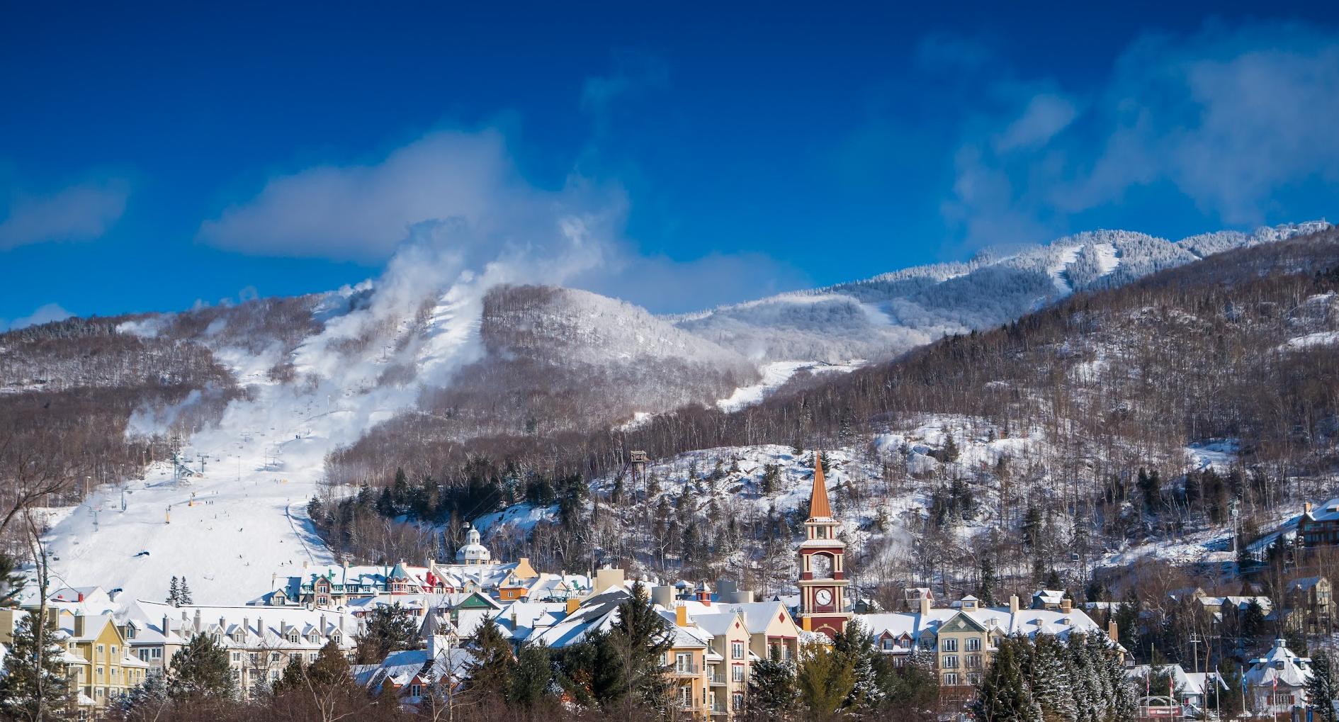
TransTerrebonne
Parc
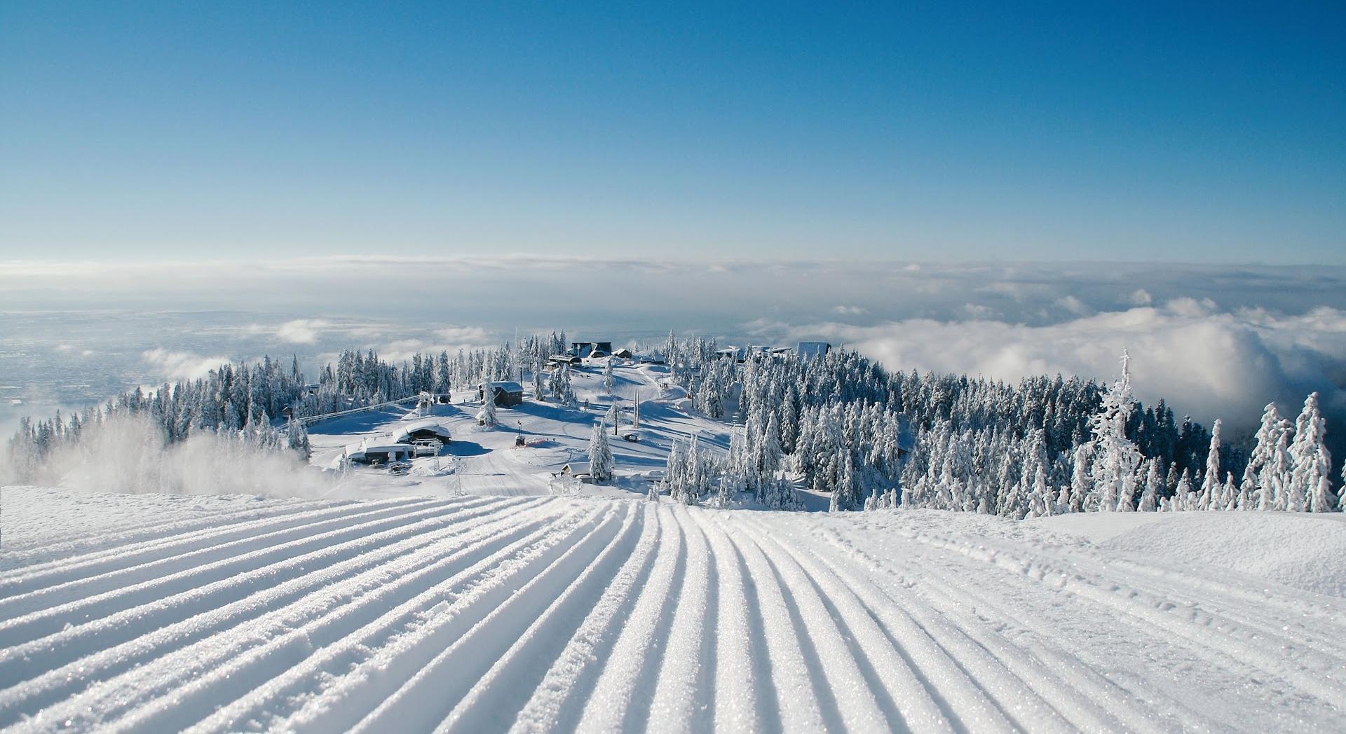
Ski de fond Moulin
Hardy Lake Trail Head
Huckleberry Rock Lookout Trail
Lynn Peak
Baden Powell Trail
Cove Cliff
Quarry Rock
Pioneer Trail
Sentiers des Pionniers
Reviews


The best part was reaching the top of the rock and seeing the amazing view. I felt a rush of adrenaline and excitement as I walked on the rock, which was a bit dangerous but also fun!


Beautiful place for a winter walk with friends.


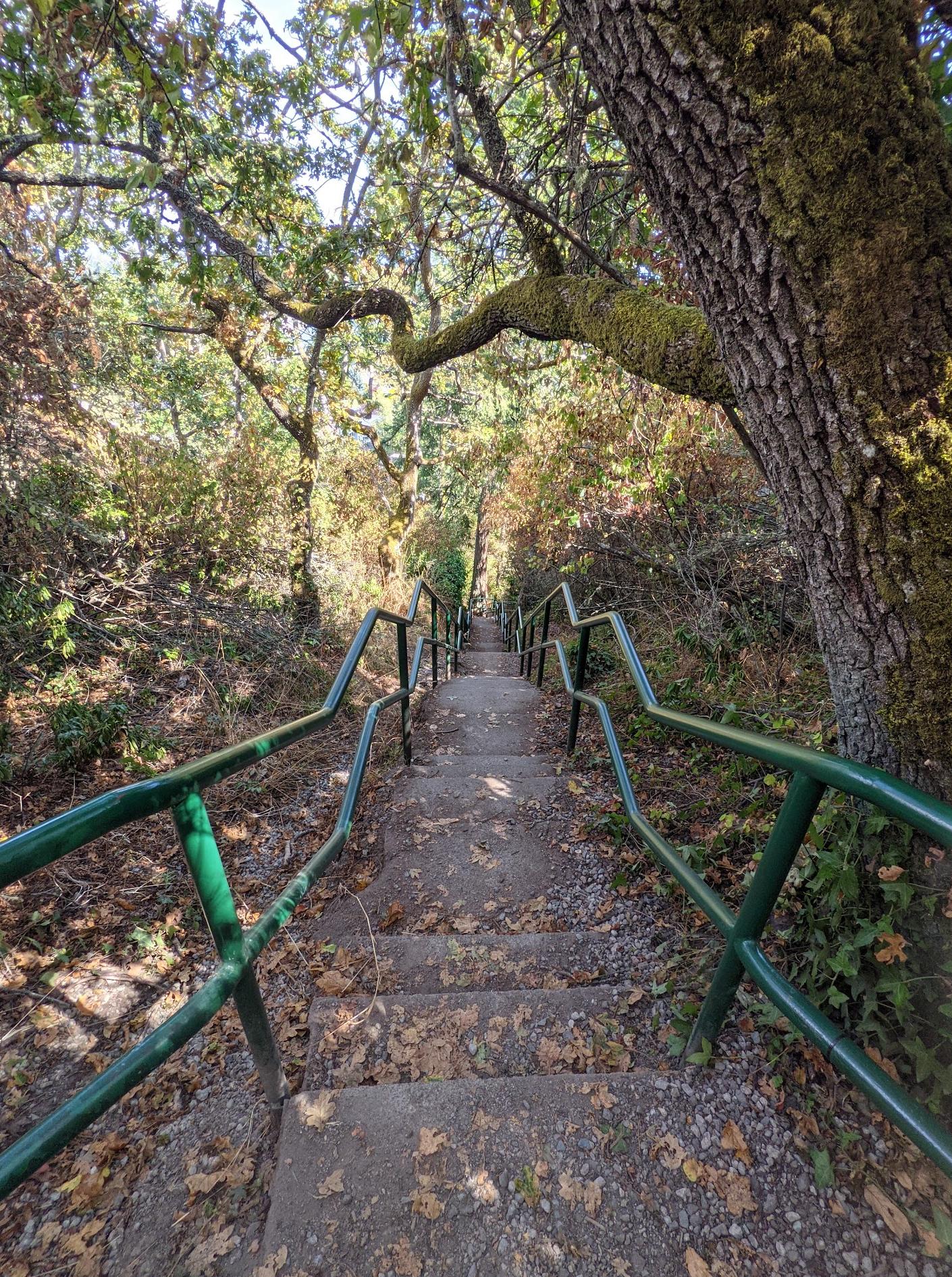
This is a hiking trail near the Deep Bay Park, which is about 2 kilometers long and about 2 hours round-tip. It is not difficult to hike, and there are many wooden steps. There are many creeks and small waterfalls along the way. The towering trees stand in the mountains, and the forest air is very fresh.
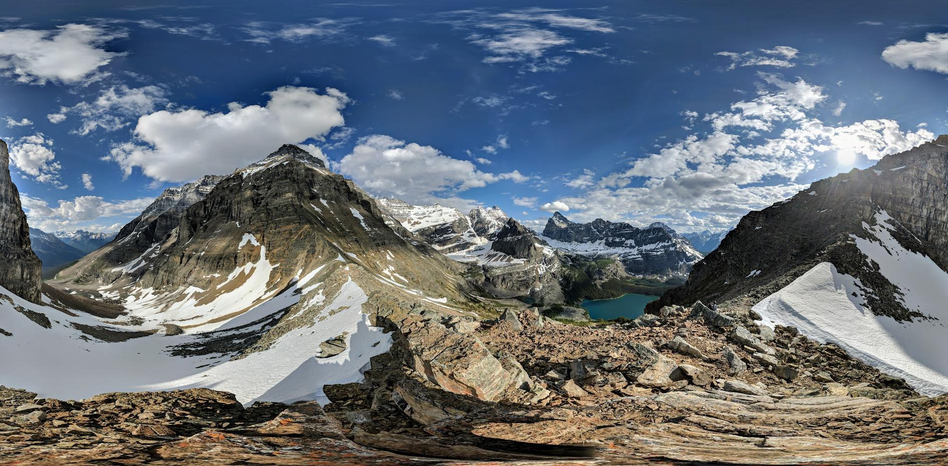
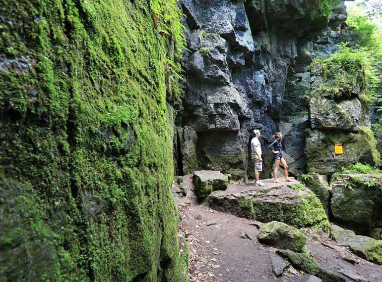
After 40 minutes up the mountain, you can reach a large rocky outcrop known as Quarry Rock (also known as Grey Rock in some hiking books). Here you can enjoy the scenic views of the mountains around Belcarra and cities in the distance. At the foot is the Deep Bay, where there are large ships and many moving kayaks on the ocean.
After 40 minutes up the mountain, you can reach a large rocky outcrop known as Quarry Rock (also known as Grey Rock in some hiking books). Here you can enjoy the scenic views of the mountains around Belcarra and cities in the distance. At the foot is the Deep Bay, where there are large ships and many moving kayaks on the ocean.


Die Wanderung ist etwas anstrengend, aber auch für Anfänger super machbar! Man kann sich super oben hinsetzten, etwas essen und trinken und auch ein bisschen bei der schönen Aussicht entspannen. Wir waren am Wochenende dort und es war nicht mal zu voll. Man sollte passende Kleidung nehmen, beim Wandern kann es schnell warm werden, während es am Ziel dann eher etwas kalt ist.


Hello lovelies,
About Quarry Rock I would say it's a nice and easy trail to hike and to walk your dogs. As soon as you get up there you'll see a very gorgeous view which is spectacular and breathtaking 😍
It took us 40 min to get up there and 35 min to get back down to the street.
Try it and enjoy a healthy day 😉
About Quarry Rock I would say it's a nice and easy trail to hike and to walk your dogs. As soon as you get up there you'll see a very gorgeous view which is spectacular and breathtaking 😍
It took us 40 min to get up there and 35 min to get back down to the street.
Try it and enjoy a healthy day 😉


Nice easy out and back hike, with gorgeous views on a clear day. The trail was very well marked and there were a lot of people on the trail: hiking, running and dog walking.
Dogs are allowed on this trail, and in some sections they do not need to be on leash.
Definitely check out "Honey Doughnuts" after the hike if you have time, they have such good doughnuts 😍
Dogs are allowed on this trail, and in some sections they do not need to be on leash.
Definitely check out "Honey Doughnuts" after the hike if you have time, they have such good doughnuts 😍


Beautiful hike that’s not too difficult, kid friendly. It can be very crowded as it very popular. Takes about an hour and half.


It was a nice, easy short hike with a
stunning view at the top on a clear day... Excellent trail for family with kids......Trail was tight in a few spots....busy trail, crowded on weekends... Limited parking at Deep Cove main parking lot. Please practice #LNT leave no trace
stunning view at the top on a clear day... Excellent trail for family with kids......Trail was tight in a few spots....busy trail, crowded on weekends... Limited parking at Deep Cove main parking lot. Please practice #LNT leave no trace


an easy and extremely delightful hike. about 40min to go up (2.2km) and 30min to come down. the view is breathtaking.


Just an easy 10 minute climb. We found it fairly easy to follow the markers. The view at the lookout is outstanding.


The lookout is fabulous. You can spot some lakes and fall colours from the top. It’s a moderate level trail where you hike up through rocky stretches. Follow the white markings to reach the lookout point.


A great place for a short hike and a great lookout! This place starts off with a decent climb up a rock surface, when you reach the top of the hike it opens up to a wide expanse of rock and trees, you can basically choose your own path to explore, there are some lightly "labeled" parts of the trail which you can follow for the quickest route to the lookout, but I usually choose to just go nuts and explore wherever I can. With this method you can spend over an hour here easy, jumping over roots and rocks, climbing little bouldery sections, finding tight squeezes through bramble. Otherwise you can just follow the blazes along the trail, which means you'd spend much less time here, but it's still a good time! It's worth a visit every now and then, but too often, and you'd run out of things to do.


Incredible bike/hiking trail with heavy dips that arch almost 50°, I highly recommend using your electric bike unless you're hard core like my husband who did it once on his regular bike ut he had to walk it up some of the hill because the tires would just spin out from the extensive icline. Beautiful colors and many deep ravines that take you breath away, amazing place, highly recommend.


Really enjoyed this one. It had it all: rocks, roots, views, inclines, a loop, interesting topography. Not very difficult or long
Dawn or dusk i think both will be good to see.. not sure about the mid of the day.
I hear rattle sounds not sure its rattlesnake whatever it may beware of it
Dawn or dusk i think both will be good to see.. not sure about the mid of the day.
I hear rattle sounds not sure its rattlesnake whatever it may beware of it

Nice short and easy hike. Well maintained with self guided plaques.


What a gorgeous park! Feels like a maze hiking up the trail but it's so worth it.

Bien entretenu quelques ptites côtes juste assez pour se dépasser
On est chanceux d'avoir ça a coté de chez nous
On est chanceux d'avoir ça a coté de chez nous

Super a marcher. Il y a de belles cotes. Excellent pour les cuisses. Le reste...dans le bois, calme. Un excellent moment


This is hands down the best place on this planet to see the sunset. Hike is just for about 20mins v easy. Its a hidden gem. U see the sun setting and beautiful trees and islands surrounded by lake at the bottom. Its no less than heaven.


Nicely laid out trails. I may have missed it, but I didn't see any washroom facilities in the main parking area. I believe it is important to make them available along with recycle bins at the start.

Je trouve qu'elle n'est pas bien entretenu vous ne passé pas souvent la machine. Maintenant je n'ai plus le goût d'y retourner. Je préfère St-Anne des plaines et seignerie


Nice place to see sunset. We went on the evening, the hike was easy and the views were rewarding. It is not stroller friendly coz of the terrain. Initial path is forest floor and the rest are rocky.


I've been here with snow on the ground, and in the spring and the summer. I have enjoyed it every time. Lovely flat rocky area with moss and dead trees for cool photo opportunities and a lovely lookout. Great for sunset. Bring a little picnic and hang out up top.


Really nice parc, cool hydro dam. Tuttles!!!

The trail is well-maintained, and views were very good indeed. When I visited there, weather was perfect as well. I went there by bicycle, so it was a bit hard to go super-long uphill, but I managed it ok.


Scenic little hiking area.


This is a challenging hike. A must is bear spray, a bear bell and a knife for protection. This hike is in the back country. Also a must is good hiking shoes or boots, a hiking stick for the decend and water and a snack for your break at the top. I loved this hike and the view was well worth the 4hrs it took me to get to the top.


Absolutely loved this trail, did the shortest one, beautiful scenery, so peaceful & calm. Love that there are not cottages or boats on this lake, so quite, a meditators dream.


쿼리락으로 가는 하이킹 코스의 출발지점. 쿼리락까지 한 시간에서 한시간 삼십분 정도 걸리지만 코스가 어렵지 않습니다.


My wife and I were at the family cottage nearby and stopped in for a hike, we chose the 9km trail, and if you're up for a good lengthy hike we highly suggest it! Certain spots on the trail are quite muddy/boggy and the bugs love it there so be prepared with the bug spray! Several beautiful spots to stop and enjoy a beer and a swim.


I hiked there on MAY. It was long uphill like grouse mountain. However, a few hiker are there and also it was very calm and relax mood.
Around the peak, trails are covered with snow. But you do not need snow shoes.
Around the peak, trails are covered with snow. But you do not need snow shoes.


有观望台,有飞碟射箭场,免费停车场


Great place to hike! Spring, summer,fall, or winter! This provincial park, about 1.5 hours away from Toronto, is sure to keep in touch with the best nature has to offer! You can spend a good couple of hours completing the trail around the lake!

Amusant avec pitou!

Très beau parc et propre

Excellent for fat bike riding.


Beautiful and very long trail. We were on our way to Seymour but due to not having day pass we came back 1-2 kms from pass check point and went to this trail towards deep cove direction. It was snowy and slippery. Having microspikes on your shoes will make it easier. Although we managed to walk in normal hiking shoes with caution. From parking it is descending towards deep cove so coming back takes some effort.
Top!


Went there at the tail-end of fall-colors to avoid the crowds. Yet could only park on the roadside. A great trail to spend a few hours. Some sections of the trail was covered by leaves and mud, we need Google map to help find the way, kind of fun.


Great place to view fall colors in Muskoka. Go in the early morning to avoid the crowds. Parking spaces are limited. Very busy in the afternoon and you have to park along roadside. You can either go for a easy hike of 3 km, or a challenging 8 km hike. The lake view are beautiful.


So beautiful Hardy Lake with moderately loop trail about 8-9 kilometres. A good place hiking with families. The parking lot is limited that if you come late has to parking along the road. Should be careful about sloppy and muddy road.


This is a great hike. The trail signs are confusing, I suggest you use All Trails app or download a trail map. You can hike anywhere from a 3km loop to a 6km to 8km or even 10. This is a moderate to advance hike. I would say some parts are challenging for small children and people with mobility issues - I would recommend the 3k for those groups.
There are a few spots for swimming and a napsack lunch. In bug season, you are going to get lots of hugs - bring repellent!
If there has been heavy rains, you will get lots of muddy sections and need good waterproof hikers or have good balance to walk across wet logs and stones.
It is very rare to see an undeveloped lake in this area, so any hiking challenge is worth it. I would suggest you try to go on off hours (early morning/late afternoon) or off season. This hike can get crowded. I have picked times when maybe I encountered a dozen other hikers on the trails and the peace and quiet of hike like that is worth the price of a week in a spa!
Enjoy and Google chip wagon near me if you want a guilty treat after burning off those hiking calories.

Love going there away from city noise sit and think or relax by the water see all the little critters it does the mind good


Every big city has trails for your fitness needs and the Ottawa/Gatineau area has endless trails. On both sides of the river you can hike or bike or run for miles. And both cities are connected which is great! This trail takes you into part of the Gatineau Park and it’s very nice! 👍😎

Nice short trail. Took us maybe 30 minutes but we stopped to read all the little signs and identified the trees noted. There's a few benches on the trail as well which is nice.


I’ve been living in Parc Champlain for a few years now. It’s been quiet and pleasant and the pathway has been my go to for walking, cycling etc. It gets old after a while but it’s been a bonus having it so close. It’s very scenic in the fall. Lots of photos to be had of dead wood, trees, branches, mushrooms etc if you’re into that sort of thing ☺️


Very easy and scenic pathway located just to the south The Plateau and ideal for leisurely strolls through the woods solo or with the kids. Most places should be easy enough with a stroller or with walking assisted devices. Large variety of plant life.


Nice, easy, family friendly trail. You might even see some wildlife like deer.


Small loop that took us probably 20 mins, one way traffic during covid, one of few dog friendly trails during winter in Gatineau.


Well maintained trail and easy to trek. Accessed from Indian Mountain Drive, as Deep Cove entrance is closed due to Covid. No snow but lots of muddy spots.


Je crois que le maire de Terrebonne c'est dit, faisons des parcs connectés toutes ensemble et mettons peu de signalisation pour que les gens se perdre dans tous les parcs. C'est comme ça que je me suis senti dans le transterrebonne "tout comme dans le parc croteau" mais l'endroit est très beau pour autant, surtout en automne. je crois que c'est surtout pour les gens à vélo que les piétons, vu la grandeur du parc. Le paysage est très pareil partout, pas de lac ou différent points de vue dans la randonnée qui est un point negatif.


Highly recommending! Don’t be afraid of intermediate trail level, it is ok to climb up around 1 hr. From downtown Vancouver you can take the bus 211. Honestly I would prefer this trail then the Calipano park which costs around 50$ for the admission. The view on top is incredible and speechless.


Nice, short trail and easy for beginners.


Well maintained trail with moderate intensity, about 1.5 to 2 hours to the Quarry rock and back, with stairs, trails and more. Great 1 day getaway trip for the family as the surrounding areas are family friendly. Parking can be difficult but it is well marked where you can and can't park. Suggest to go there early, we arrived around 9:30 parking was not a problem, cars lined up as we leaving around noon. Great view from the Quarry rock, it's a open area with no fence so use common sense at the of the rock. I've seen people flying drones there and no sign saying you can't, looks very fun.


We've all heard of Glamping, well this hike was like #gliking with all the wooden stairs that were built through the forest. Don't get me wrong there's still lots of areas where you need to walk over tree roots, but the stairs are a work of great craftsmanship. Beautiful view at the end.


I went on late January during a supposedly sunny weekend which turned out to be cloudy, but when I reach the peak, I was welcomed by the heavenly view of a sea of clouds.
The first 15% of the trail is the hardest for me because it was steep and rocky with plenty of fist-sized wobbly pebbles. It felt even worse when descending.
Around halfway to the top it became easier with less steep and a wider dirth path. Here, if you look to your left while ascending, you can spot what looked like an aftermath of a landslide or boulderslide from a long time ago. First you will see a couple of big boulders and an upward trail of broken trees behind them.
During winter season, around 75% onto the peak, you will start seeing snow and soon the entire path will be covered by snow.
Weirdly enough, I barely felt cold at all. I even had to take off my thick jacket even with the snowy landscape all around me. In fact, it felt much colder in the city rather than up there.
I would recommend trying this trail during winter because it might be boring in the latter half of the climb without the snowy view and landscape.


I absolutely love this hike. The trail is rough, and it really helps that I'm tall. It's a bit of a challenging trail, lots of loose rocks at steep slopes, but lots of stuff to hold onto as you scale it.
I first did this two years ago as a night hike, and then again last may, and again this may for another night hike.
Has a good view of the eastern side of greater vancouver
I first did this two years ago as a night hike, and then again last may, and again this may for another night hike.
Has a good view of the eastern side of greater vancouver


The end of the trail at Quarry Rock is really worth it ! But the trail itself is not very interesting. Lots of stairs and despite a few tiny waterfalls, nothing interesting to be seen before reaching the end.


I run up Lynn Peak regularly as part of my ultramarathon training. It's a great trail with a view from the lookout that is more than worth it on a clear day.
The typical hike takes you to a bluff overlooking North Vancouver, out towards the Fraser Valley and down towards the United States. The actual summit, of which there are two, is further along the ridge and rarely visited by the general public. You're not missing out on anything if you don't go there as the view is extremely limited and just not worth the additional effort.
The trail itself is very technical and appropriate footwear should be worn. The trail is also steep in places, so be prepared for that and allow plenty of time to hike back down again too. Unlike Grouse Mountain, there is no gondola here to transport you back to the parking lot. If it's been raining a lot, much of the trail becomes a creek, so it's not uncommon to feel like you're hiking up a waterfall in the winter months. Again, be prepared for this.
The hike is about a 9km return trip from the upper parking lot and should take around 3-4 hours if you're taking it easy and stopping for photos. Enjoy!


This is an easy short trail, just 1.3 k.m., 20 minutes you'll be done. It winds through some beautiful forest and is a small sample of what Gatineau Park has to offer.


It was still a bit snowy when I went in the end of February so I recommend getting hiking shoes. I went super early at 6am and was the second one on the trail. It is a pretty easy hike if you have proper shoes and during the warmer seasons. I love the view and the little streams of water and bridges that you pass by during the hike. Definitely recommend going earlier to avoid the hoards of people and dogs.


Not an easy hike but lots of fun. A few technical sections and respectable elevation gain. Decent views but nothing spectacular


Very nice trail, it's not too challenging. I would recommend good pair of shoes or minimum close toe. There are couple of slippery areas. During certain times of the day the trail gets overly packed. With too much foot traffic it gets hard to navigate. The view at the end is breath taking beautiful.


Intermediate trail. Vancouver trail has pretty accurate information. It's about 4 hours hike for average hikers. The first quarter is steel and full of rocks and debris. It can become slippery and more challenging after it rains.
The view on the top is nice and rewarding after the hiking!
The view on the top is nice and rewarding after the hiking!


It was a long walk up similar to the Grind. Went on a less than ideal day so there was zero view. Even on a good day there is only a couple of spots with a view. The parking lots are extremely busy I arrived at 8 and almost didn't get a spot in the closer parking lot. The trail is quiet once you get off the main loop.